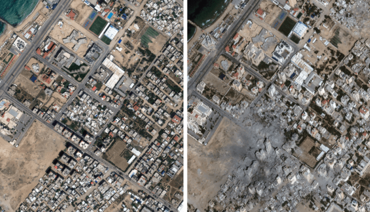
Satellite images show destruction from Israel’s assault on Gaza
The Israeli military has destroyed nearly 200,000 housing units, either completely or partially, since the start of its latest assault on the Gaza Strip following Hamas’s surprise attack on October 7.
Mohammad Ziyara, the Palestinian minister of public works and housing, said on Thursday the bombardment has “erased entire families from the civil registry,”, as well as “neighbourhoods and residential communities”.
“[It] also destroyed facilities, including hospitals, places of worship, bakeries, water filling stations, markets, schools, and educational and service institutions,” Ziyara added in a statement.
Home to some 2.3 million people, the Gaza Strip covers a tiny area of 365sq km (141sq miles).
According to the UN’s humanitarian office, at least 45 percent of all housing units in the enclave have been damaged or destroyed in the Israeli attacks. Among the areas hit the hardest have been Beit Hanoon, Beit Lahiya, Shujaiya, the neighbourhoods around the Shati refugee camp, and Abasan al-Kabira in Khan Younis.
Drag the slider to the left to see what remains of some of Gaza’s neighbourhoods.
An estimated 1.4 million people in Gaza have been internally displaced due to the relentless bombardment, with some 629,000 sheltering in 150 UN-designated emergency shelters.
Meanwhile, Israel’s total blockade on fuel entering the enclave is seriously affecting critical functions in all hospitals, risking the lives of at least 130 premature babies in incubators, 1,000 kidney dialysis patients who have had to reduce their treatment sessions, and front-line ambulance workers who cannot access the sick when the fuel runs out.
Since 2007, when Hamas came to power, Israel has maintained strict control over Gaza’s airspace and territorial waters and restricted the movement of goods and people in and out of the enclave.


