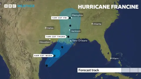
Louisiana braces as Hurricane Francine barrels in
Louisiana is bracing for Hurricane Francine as the storm grows in power over the Gulf of Mexico before its expected landfall on Wednesday.
Francine strengthened from a tropical storm into a Category 1 hurricane on Tuesday and is expected to have reached Category 2 when it hits Louisiana, the National Hurricane Center (NHC) said.
Louisiana and neighbouring Mississippi have declared states of emergency in preparation for landfall.
Francine will bring 4-8 inches (10-20cm) of rainfall, potential tornadoes and damaging winds to much of central and eastern Louisiana, forecasters said.
The very wettest places could see up to 12in (300mm) of rain, bringing the risk of significant flash flooding.
Residents in eastern Louisiana, Mississippi, southern Alabama and western Florida were warned of a life-threatening storm surge and urged to finish their hurricane preparations by Tuesday evening.
A storm surge means there is a danger of water rising from the coastline and moving inland. In some places, water may rise up to 10ft (3m).
“You’re going to want to be in your safe space to ride out the storm likely by tonight,” said Michael Brennan, director of the NHC, in an update on Tuesday.
He added people should have a plan to shelter in place until Thursday.
The hurricane is expected to bring “considerable” flash and urban flooding in parts of Louisiana, including New Orleans, the NHC warned.
Several of the state’s coastal parishes are under voluntary or mandatory evacuation orders. Some schools and colleges have already closed, while US oil and gas companies on the Gulf of Mexico, including Exxon Mobil and Shell, have evacuated staff and paused some operations.

Mr Brennan said residents could expect widespread power outages, tree damage and structural damage inland up to the west of the New Orleans metropolitan area.
Louisiana recently marked the 19th anniversary of Hurricane Katrina, which killed more than 1,800 people and caused widespread devastation.
Nearby Texas is also preparing for the storm. Governor Greg Abbott urged residents on Tuesday to heed guidance by local officials, including possible evacuation orders.
While the potential hurricane is expected to make landfall in Louisiana, Abbott warned “the predicted pathway of a storm like this doesn’t always turn out to be true.”
“As a result we need to be prepared for the possibility that conditions could change,” he said.
His state has mobilised resources and deployed water rescue teams, he said, and is prepared to call on the National Guard for support if needed.
Francine’s development follows a quiet August and early September during the Atlantic hurricane season, which typically lasts until November. Experts earlier this summer had predicted a busier season.
Sarah Keith-Lucas, a weather presenter with the BBC, said the hurricane followed “a very quiet spell of weather in the Atlantic basin”.
“The previous named storm in the region was Ernesto, back on 12 August,” she said.
“The last time we had no named storms during this same period was back in 1968. Usually, this time of the year is peak hurricane season. Last year nine named storms formed between 13 August and 8 September.”
As of Tuesday evening, Tropical Storm Francine, the sixth named storm of 2024, was about 360 miles (579km) southwest of Morgan City, Louisiana, a town overlooking the Gulf of Mexico.
Hurricanes are categorised on a scale of one to five. Category five storms are the most destructive, with winds in excess of 157mph (250km/h).
There were 19 named storms in last year’s hurricane season.


